Isle of Man Aerial

Up

This site is a personal web site run by John Saville and is not endorsed by Enesco or the Lilliput Lane Collectors Club. All information is provided on a "best efforts" basis and no responsibility can be taken for lost time or finance if relied on.             Webmaster: john-saville@ntlworld.com
Picture of LL Model Name Original Town Visit LL Ref. Dates Actual Location Grid Reference IoE
Tower of Refuge Douglas . . Jun 09 Conister Rock at the southern end of Douglas Bay N54.1500 W4.4705 N/A

 aerial photo above: JRS     Pic

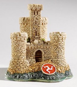
Lilliput Lane's "Tower of Refuge" is based on the Tower of Refuge on Conister Rock (reef also known as St Mary's Isle) at the southern end of Douglas Bay
Port ERin Port St Mary
  The mountains
near Ronaldsway near Port Soderack ....towards Douglas
towards Douglas Douglas Bay

This is a personal website run by John Saville.  All web pages are Copyright John Saville as are all photographs unless otherwise indicated. Other information (e.g. maps etc) may be copyright to others as indicated. No information may be copied or reproduced without prior permission (from: john-saville@ntlworld.com) but this will almost certainly be willingly granted.